On Thursday March 10th, we took some test aerial images around Lawrence. We had several reasons for taking to the skies with the E-5:
- What is the best focal length for our project?
- What is the best focal length, f-stop, and lens combination that will give us the best resolution for our project needs?
- Can we rely on Aperture Priority mode and what f-stop can we use without motion blur in our images?
- Production of test images so we can find which post-processing methods will be better for phase II projects.
- Getting a 'feel' for the effect of elevation on image resolution.
- Getting a qualitative 'feel' for what our images may look like when they are attached to the balloon.
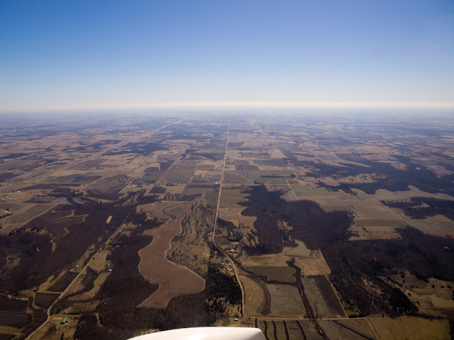
Taking nadir looking photos from the window of an airplane moving around 100 mph was difficult. The wind was very strong and very cold. The articulating screen and digital level of the Olympus E-5 helped immensely by letting me hold the camera out the window, and while the camera is was facing downward, being able to see both the subject and at what the camera angle was.

Figure Vijay, our pilot Victor, and Ryan. Taken with an Olympus E-PL2.

Nadir-looking image of KU's experimental algae pool north of Lawrence. Taken with the E-5 and 12-60 Zuiko lens at 4500ft. Camera settings: 30mm f/3.6 1/3600 sec.

200% crop of previous picture. Each circular pool here is 3m in diameter.

Quail Run Elementary School in Lawrence. Taken with Olympus E-5 looking straight down. Camera Setting: 40mm f/3.8 1/2500 sec.

100% crop of previous photo. You can see the kids at recess.
Overall, we were impressed with how well the camera was able to resolve images, especially considering the conditions under which the photos were taken; handheld out the window of a fast moving airplane. We are still looking through the images. More to come.

- ryan callihan - camera team